art direction, design + typography
From the reference box #135


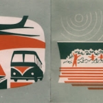
It covers current and proposed land use residential and commercial (this was immediately after the war and much of the city needed re-development), looks at traffic & public transport solutions, population density problems and shows plans for the Thames riverside re-development. All of which are illustrated with these wonderful infographics...


For more delightful ephemera have a dig around the rest of our reference box here.
https%3A%2F%2Fwww.deliciousindustries.com%2Ffrom-the-reference-box-135
Delicious+Industries%3A+From+the+reference+box+%23135
Welcome
Welcome to the Delicious Industries blog. We're an independent design studio based in Brighton, UK and this is our scrapbook packed full of design, illustration, photography & typography inspiration. Check out our work here.
Links
DELICIOUS FRIENDS
DELICIOUS FAVOURITES
- 50 Watts
- Acejet 170
- Grain Edit
- It's Nice That
- National Geographic Found
- Notcot
- Pretty Clever
- Retronaut
- So Much Pileup
- We Love Typography
- Another Mag